
Showing posts with label maps. Show all posts
Showing posts with label maps. Show all posts
Tuesday, January 22, 2008
Late Addition to Indian Hills Boundary
Final boundary recommendation was posted on the HSD website (link).
Based on some requests from a family in the Reedville boundary to keep them with their neighborhood the boundary has been extended down to below SW Trelane from Johnson. This adds 59 houses into the Indian Hills boundary from what was presented in Plan 6 and approved in the working meeting last week.
Since this change was not discussed fully in the working meeting I have no idea how many kids this adds to the total for Indian Hills. When the initial request was reviewed in the meeting (and, it appeared, rejected) the initial response was that it was 60-some kids but that doesn't make sense when looking at the number of homes.
Still waiting for the district to publish capacity and projected attendance for the new boundaries after asking in 2 meetings. I'm not sure how we can give meaningful input to the board without having a way to measure equity, a key goal of the committee.
I will post an updated map soon.
Monday, January 7, 2008
ES #27 Draft Boundary
Click to zoom...boundary for new school shown in orange stripe. This was drawn on my own map from the overhead, this is by no means official, even as a draft.
New area will be taken from west side of Ladd Acres at Imlay Ave south of Golden over to west of Brookwood into Witch Hazel, reach down south of TV to Alexandar then connect with the S. Hillsboro area around the new school. In addition they will take the small section directly east of Frances Street Park from Imlay to Ladd Acres.

New area will be taken from west side of Ladd Acres at Imlay Ave south of Golden over to west of Brookwood into Witch Hazel, reach down south of TV to Alexandar then connect with the S. Hillsboro area around the new school. In addition they will take the small section directly east of Frances Street Park from Imlay to Ladd Acres.

Thursday, December 20, 2007

Plan 6 Details on HSD Website
Plan 6 Presentation
Shows updated feeders and boundaries, Indian Hills with a 43 student increase (grades 1-6), same as Plan 3. Ladd Acres is restored to original boundaries, Butternut will feed to Brown/Century while Orenco goes back to Poynter/Liberty.
Butternut parents will be very upset, they wanted to stay as Hilhi Spartans but they spent the last few meetings complaining about Brookwood coming out of Hilhi. Now Brookwood is back to Hilhi and Butternut moves to Century.
Sunday, December 16, 2007

Sunday, December 9, 2007

Thursday, November 29, 2007
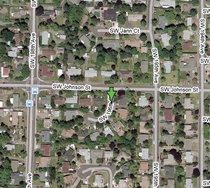
Indian Hills Neighbor: Can you fit 2 more?
One of the parents at tonight's meeting mentioned that most of the kids in her neighborhood are being moved from Reedville to Indian Hills, the boundary is at Johnson, just north of her cul de sac.
Her 2 kids would have to wait for the bus alone or walk more than 2 blocks to join other kids. If they go to Indian Hills, they will be able to take the bus with the same group of kids that they ride with to Reedville now.
Here is her cul de sac:

This should be a no-brainer. Robin asked for specifics on the street name after hearing the comment and in my experience the committee typically will accommodate, even if it is just a couple kids. [edit - for clarity]
My opinion? Welcome to Indian Hills!
Her 2 kids would have to wait for the bus alone or walk more than 2 blocks to join other kids. If they go to Indian Hills, they will be able to take the bus with the same group of kids that they ride with to Reedville now.
Here is her cul de sac:
This should be a no-brainer. Robin asked for specifics on the street name after hearing the comment and in my experience the committee typically will accommodate, even if it is just a couple kids. [edit - for clarity]
My opinion? Welcome to Indian Hills!
Tuesday, November 20, 2007
The Core
I was initially uneasy about the boundary process (and assumed the worst) when I looked at elementary school administrators on the committee and the schools they represent. Since then, the actions of the committee turned my assumptions upside down, they clearly listened to Indian Hills parents and it wasn't about where we're from.
Right now Eastwood is taking a hit straight to the jaw on redistribution of students and their principal is on the committee; there is no magic force field granted by the position. In fact, it must be much harder to look the parents in the eye and say, "Yes, I am part of the committee and I concur with this proposed change." Who would ask to be put in that spot?
However, I have finally been able to illustrate my initial concern in the picture below. On the left is a map of all elementary schools with North Plains far to the north and Groner way down south, on the right are elementary schools with administrators on the committee.

Next time can we include at least one elementary administrator from outside Hillsboro City Limits?
Will it make a difference in the outcome? Probably not.
Will it make a difference in how folks in unincorporated Washington County or outlying communities feel about the process? You betcha.
[edit - some changes on a couple paras for clarity]
Monday, November 19, 2007
Updated HSD Plan 3, showing tax lots
This is what will be shared at the Public Meeting tonight. I will be present to make sure everyone knows, still holding a INDIAN HILLS sign.
Pretty much my only comment will be "thank you" - I think the comments from the parents last Wednesday really made a difference. I didn't really even get to say anything meaningful to the committee. All that matters is the results, in the end.
NO HOME EXCLUDED FROM THE CURRENT 2007 BOUNDARY, add in the black border area is the only change.
HSD Plan 3 with tax maps, area in black is ADD (click to zoom)

FLASH
Apparently the Boundary Committee is presenting PLAN 3, not currently shown here.
Go here for link (link)
All of the maps I show below are obsolete. Please review before the meeting.
I am checking them now.
[UPDATE - Original boundaries North of Rock Road and in Shadowood have been restored with addition on the East side of the current boundary still in place]
Go here for link (link)
All of the maps I show below are obsolete. Please review before the meeting.
I am checking them now.
[UPDATE - Original boundaries North of Rock Road and in Shadowood have been restored with addition on the East side of the current boundary still in place]
Wednesday, November 14, 2007
Add/Remove Map (click to zoom)
OBSOLETE (see Nov 19 post, above)
HSD Proposal #2 showing tax lots (click to zoom)

HSD Proposal #2 showing tax lots (click to zoom)

New Maps, Boundary Update
OBSOLETE (see Nov 19 post, above)
Only change to the map was that they cut out the last remaining older high density area in the proposed boundary of Indian Hills, a chunk of R15 and a bunch of apartments next to Wendy's on 198th. This is evidently what will be presented at the first public meeting on Monday.
CURRENT (click to zoom)

HSD PROPOSED PLAN 2 with zoning (click to zoom)

HSD OFFICIAL MAP (from big pdf on HSD site)
This is Plan 1, my map above shows Plan 2 as described in the meeting.

Monday, November 12, 2007
Boundary Change Overview
NOTE: This is an old post, new updated maps are HERE
CURRENT (click photo to zoom)
HSD PROPOSED with zoning (click photo to zoom)

CURRENT (click photo to zoom)

HSD PROPOSED with zoning (click photo to zoom)

Subscribe to:
Posts (Atom)
